Colorful Death Valley
When I was told by a group from the Laguna Woods Village
that they were organizing a tour to see the autumn foliage in the
Death Valley, I wasn’t convinced that such a natural wonder even
took place in the desert. I had seen beautifully colored trees on
Seorak Mountain in Korea, the Austrian Alps, Algonquin Park in
Canada, and the Yale University golf course, but I had never
known that such a famous tourist attraction existed in our nearby
vicinity.
However, I was told that the fall colors are beautiful in the
desert, by a former botanical professor in the village and that the
normally green leaves of the various deciduous trees and shrubs
in the desert turn to vibrant red and yellows for just a few weeks
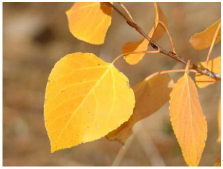
in the autumn. He explained that leaves are green because of the
presence of a pigment known as chlorophyll in their cells during
the growing season. In late summer, as daylight hours shorten
and temperatures cool, the veins that carry fluids in and out of
leaves gradually close up as a layer of special cork cells begins
to form at the base of each leaf. As the cork layer thickens, the
intake of water and minerals is reduced, causing the leaves to
change color.
In light of that information, I decided to join the tour.
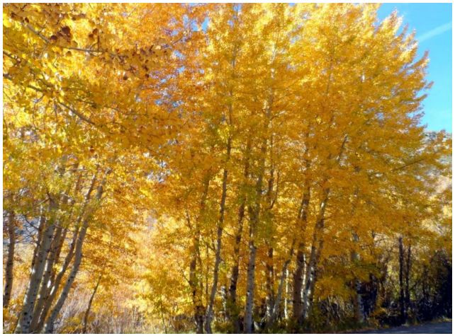
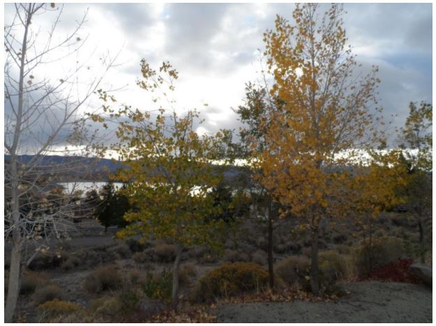
 Our tour bus left Gate #3 of the Village around 9:00 one morning during the last week of October. As soon as we pulled out, our tour guide began her introduction on what we were about to see as we headed toward the autumn foliage in Death Valley. She told us that the beautiful yellow leaves we would see would be mainly on a species of tree called a cottonwood. We’d be visiting a number of lakes with colorful names such as Convict, Topaz, Mono, June, and Silver, where cottonwoods were the dominant type of tree. Our tour bus left Gate #3 of the Village around 9:00 one morning during the last week of October. As soon as we pulled out, our tour guide began her introduction on what we were about to see as we headed toward the autumn foliage in Death Valley. She told us that the beautiful yellow leaves we would see would be mainly on a species of tree called a cottonwood. We’d be visiting a number of lakes with colorful names such as Convict, Topaz, Mono, June, and Silver, where cottonwoods were the dominant type of tree.
According to our guide, we wouldn’t be disappointed because
the cottonwoods put on a spectacular color display in the fall.
Cottonwoods were widely grown for timber along river
wetlands or lake banks, where their exceptional growth rate
provided a large crop of wood in just 10–30 years. The wood,
coarse and of fairly low value, was used for pallet boxes,
shipping crates, and for other purposes where a cheap but strong
wood was required before plastic became readily available.
I personally started my working career as an administrative
officer at Korea’s Ministry of Agriculture and Forestry right after
graduation from Korea University in 1961. As part of my duties,
I helped Koreans plant millions of Italian poplars along the
riverbanks by special order of General Park Chung-Hee, who
had just come to power following a military coup. Koreans used
poplar to make chopsticks, matches, and toothpicks. Manzanar
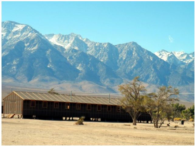
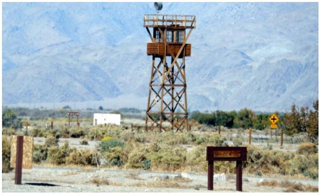
After driving five hours on Highway 395 and a number of
other roads, we finally reached Manzanar, our first stop, to see
the most widely known of the ten camps where some 120,000
Japanese-Americans were incarcerated during World War II.
Manzanar (which means “apple orchard” in Spanish) is the best-preserved of the former camp sites.
Long before the first group of Japanese-Americans arrived in
March 1942, Manzanar was home to Native Americans, who
lived in villages near several creeks in the area but abandoned
the town by 1929 after the city of Los Angeles purchased the
water rights to virtually the entire area. As different as those two
groups were, their histories each featured a common thread—
that of forced relocation. Since the last of the detainees left in
1945, former detainees and other concerned citizens have
worked to preserve Manzanar as a National Historical Site for
future generations.
Of the 120,000 people incarcerated under armed guard at
Manzanar, two-thirds were American citizens. They had
committed no crimes, there were no trials, and there were no
convictions. They were simply political detainees, unjustly
sentenced to what amounted to an American concentration camp.
After the camp closed, the site was returned to its original state.
All the structures were removed, with the exception of two
sentry posts at the entrance, the cemetery monuments, and the
former Manzanar High School auditorium, which was purchased
by Inyo County. The county then leased the auditorium to the
Veterans of Foreign Wars, who used it as a meeting facility and
community theater until 1951. After that, the building was used
as a maintenance facility by the Inyo County Road Department.
In the visitor’s center, we watched a video that showed former
President Ronald Reagan officially proclaim that the 1942
government action had been wrong and declaring that every
living detainee would be paid $20,000. As I watched, I wondered
why the Japanese government didn’t do such a thing after the
inhumane treatment of Korean women during that same war.
The Manzanar site also retains several building foundations,
portions of the water and sewer systems, the outline of the road
grid, and the remains of landscaping constructed by
detainees. The site also retains evidence of the ranches and the
town of Manzanar, as well as artifacts from the days of the
Owens Valley Paiute settlement.
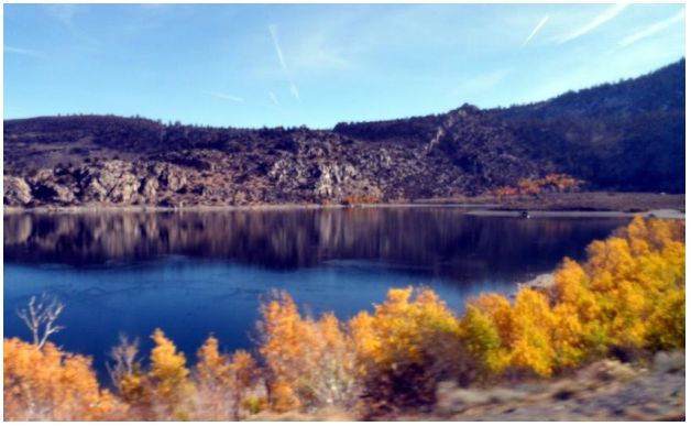
Convict Lake
I was deep in recalling childhood memories thought about
World War II, which I still remember vividly, as we drove
another hour from Manzanar to Convict Lake in the Sherwin
Range of California’s Sierra Nevada. The lake is well known for
its fishing and the dramatic mountains that surround it,
including Mount Morrison. Its surface lies at an elevation of
7,850 ft. It was wonderfully picturesque to see the yellow
cottonwood leaves and the rugged snow-covered mountains
reflected in the water.
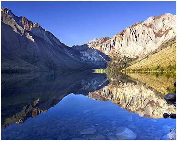
The lake was named after an incident that took place
September 23, 1871. A group of convicts escaped from prison
in Carson City and a posse from Benton, led by Deputy
Sheriff George Hightower, encountered them near the
headwaters of what is now called Convict Creek. Posse member
Robert Morrison, a Benton merchant and Wells Fargo agent, was
killed in the ensuing battle. Mt. Morrison was named after him.
Topaz Lake
Topaz Lake is a reservoir located on the California-Nevada border, about seventy-five miles south of Reno. The lake
was formed by diverting water from the West Walker River into
a nearby basin that had previously contained a smaller natural
lake. The initial construction took place in 1922. The levee and
reservoir have been owned and operated by the Walker River
Irrigation District ever since its construction.
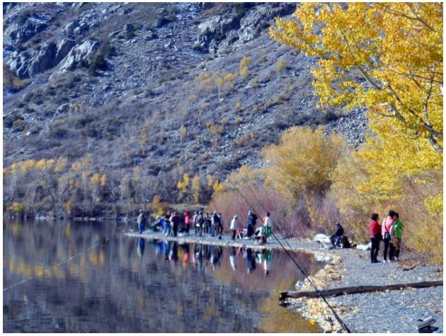
Topaz Lake is popular for boaters, water skiers, campers, and
fishermen. Fishing season runs from January 1 to September 30
and the lake is stocked with trout by both Nevada and California.
The lake is easily accessible from Highway 395. On the
northwest shore of the lake is the Topaz lodge and casino, where
we checked in for two nights. We rated the lodge at about three
stars, which was fine, since the trip was organized to be fairly
inexpensive.
On our second day, we were scheduled to visit Alpine County,
known as the Californian Alps, where an annual photography
contest is held. We were also set to bathe in the Glover Hot
Springs and to drive through Monitor Pass before returning to
the lodge. However, there was a heavy snowfall overnight on
Monitor Pass, so the itinerary was changed to include a drive to
Lake Tahoe, about 100 miles north of the lodge.
Just before we reached Carson City we stopped at Hunan, a
Chinese restaurant, to enjoy a buffet lunch in the well-developed
town of Gardnerville on Highway 395. Then we continued on to
Lake Tahoe where, as a student of the University of Oregon, I
had worked for three months in summer of 1967.
Taylor Creek
Taylor Creek is located on the south shore of beautiful Lake
Tahoe. The Stream Profile Chamber, located a quarter mile down
the Rainbow Trail, allows visitors an opportunity to study a
diverted section of Taylor Creek through a panel of aquarium-like windows. It is a major attraction for local conservation and
environmental education programs. A 180-degree curved
diorama illustrates life both above and below the water. That
diorama features a mural displaying all the seasons at Taylor
Creek.
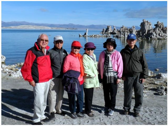
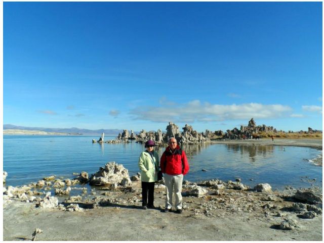
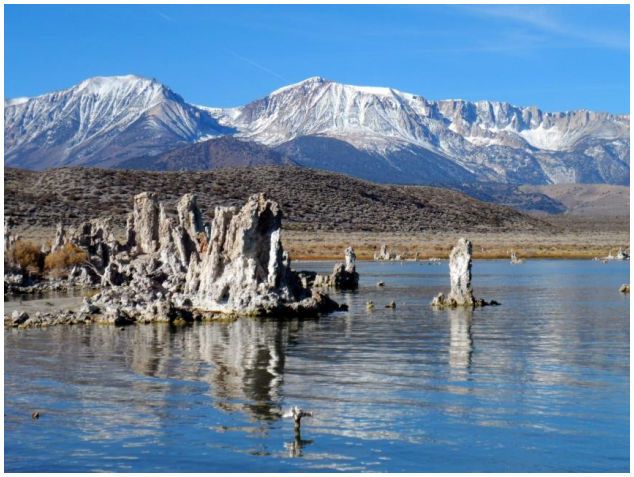
Mono Lake
Mono Lake is a large, shallow, saline soda lake in Mono
County, California, formed at least 760,000 years ago as a
terminal lake in a basin that had no outlet to the ocean, according
to brochures in the visitor’s center. The lack of an outlet caused a
high level of salt to accumulate in the lake, making the water
quite alkaline.
The lake has an unusually productive ecosystem based on the
brine shrimp that thrive in its waters. It also provides critical
nesting habitat for more than two million migratory birds that
feed on the shrimp.
Mono Lake is in a geologically active area at the north end of
the Mono-Inyo Craters volcanic chain and is close to Long
Valley Caldera. The most recent eruption occurred a mere 350
years ago.
In 1941, the Los Angeles Department of Water and Power
began diverting Mono Lake’s tributary streams 350 miles south
to meet the growing water demands of the city. Deprived of its
freshwater sources, the volume of Mono Lake was cut by half
and its salinity doubled. Unable to adapt to such drastically
changing conditions in such a short period of time, the
ecosystem began to collapse. Islands that had previously
contained important nesting sites became peninsulas that were
vulnerable to predation by mammals and reptiles. Photosynthetic
rates of algae, the base of the food chain, were reduced and the
reproductive ability of the lake’s brine shrimp was impaired.
Air quality also decreased as the exposed lake bed became the
source of airborne particulate matter, violating the Clean Air Act.
If something hadn’t been done, Mono Lake would have become
a lifeless chemical sump.
Appalled by that prospect, David Gaines formed the Mono
Lake Committee in 1978 and began talking to conservation clubs,
schools, service organizations, legislators, lawyers, and anyone
else who would listen about the lake’s value. Under Gaines’s
leadership, Mono Lake Committee membership grew to 20,000
and ultimately gained legal and legislative recognition for Mono
Lake. Since its establishment, the committee has gained many
victories in its fight to protect Mono Lake, with the help of the
public and a coalition of government agencies and non-profit
groups.
Tufa
The unusual rock formations that grace Mono Lake’s shores
are known as tufa. It is essentially common limestone, but what
makes tufa uncommon is the way it forms.
Typically, underwater springs rich in calcium mix with lake
water rich in carbonates. As the calcium comes in contact with
the carbonates, a chemical reaction occurs, resulting in calcium
carbonate—also known as limestone.
The calcium carbonate precipitates around the spring, and
over the course of centuries, a tufa tower forms. Growing
exclusively under water, some tufa towers grow to heights of
more than thirty feet. The reason it’s possible to see so many tufa
towers around Mono Lake today is because the lake level has
fallen dramatically since 1941.
June Lake
June Lake is located on the other side of Highway 390 from
the Mono Lake, at an elevation of 7654 feet. The majority of the
developed community is spread narrowly along a five-mile
stretch of California State Route 158 (which is also known either
as June Lake Loop Road or Boulder Drive in the populated
areas.)
June Lake’s valley, often described as a horseshoe canyon,
was formed by glacial action. The Rush Creek glacier split in
two when it encountered the resistant rock of what is now known
as Reversed Peak. The main glacier flowed to the north, creating
Rush Creek Canyon. Another glacial branch turned south and
east, but its flow was impeded and eventually stopped altogether
as the granitic bedrock, since the southern branch created an
uphill path toward the volcanic area of the Mono Craters.
The community of June Lake retained its commercial vitality
through the 1970s with the addition of a bank, hardware and
paint store, welder, auto body repair, art and pottery galleries,
and other businesses. Since that time, however, there has been a
steady economic decline, spurred by the growth of the
nearby town of Mammoth Lakes, which has drawn most
commercial activity away from the outlying communities.
After the Tour
I was so impressed by the natural wonder of the scenery and
the disastrous damage to the area by human beings that I decided
I would like to see the area again in a different season, especially
the summer. The most attractive site for me was the June Lake
Loop, where I’d like to camp and fish for the giant rainbow trout
in the lake. However, I’ve been told that the huge trout are hard
to catch since they’re old and cagey and that restocking of young
trout has been curtailed almost entirely by California bec ause the
program is nearly bankrupt. Just another sad story about how
human politics can damage the environment.
In summer, I may also be able to cross Monitor Pass from
Kings Canyon of the Sequoia Mountains. It may take weeks to
explore the natural wonders, but what a wonderful part of the
Earth we live in!
Photo and Essay by Wonho Chang |


Welcome aboard our site again, Professor Chang.
And I really appreciate your travelogue written in
professional way.
While I was reading, I noticed a few facts I noticed
which are as follows;
1. If you grduated from Korea University in 1961,
you're about the same age of our medical school's
class of 64.
2. What you did help Koreans plant Populars at the
beginning of 5 16 Revolution(no matter what they
call it these days), you're one of those to be recog
nized who transformed our whole nation's Natural
Scenery, especially our beautiful mountains.
3. I can't help but mention Lake Tahoe where I visited
with my medical school friend living in Fresno long time
ago. We were supposed to ski(even though still I can't ski)
over there, I chose to spend time in Casino(for the first time
in my life), playing Black Jack(I lost $300 in several minutes
and I got up) and watched Rock Band from Australia live,
over dinner as a dinner show.
Sorry I am for my ramblings and thank you for your beautiful
photos of foliage. See you again, Sir, Prof. Chang!