 The map of Carrizo Plain National Monument
The Carrizo Plain is a large enclosed plain, approximately 50 miles (80 km) long and up to 15 miles (24 km) across, in southeastern San Luis Obispo County, California, about 100 miles (160 km) northwest of Los Angeles, California.[1] It contains the 250,000 acre (1,012 km²; 101,215 ha) Carrizo Plain National Monument, and it is the largest single native grassland remaining in California. It includes Painted Rock in the Carrizo Plain Rock Art Discontiguous District, which is listed on the National Register of Historic Places. It is one of the easiest places to view surface fractures of the San Andreas Fault which traverses below the plain.The plain extends northwest from the town of Maricopa, following the San Andreas Fault. Bordering the plain to the northeast is the Temblor Range, on the other side of which is the California Central Valley. Bordering the plain to the southwest is the Caliente Range. The community of California Valley is on the northern part of the plain. The average elevation of the plain is about 2,200 ft (700 m). Soda Lake, a 3,000-acre (12 km2) alkaline lake, is in the center of the plain with the popular Painted Rock containing Chumash and Yokut rock art nearby. As the central depression in an enclosed basin, Soda Lake receives all of the runoff from both sides of the plain. At 5,106 ft (1,556 m), Caliente Mountain, southwest of the plain, stands as the highest point in San Luis Obispo County. The climate type of the Carrizo Plain is semi-arid grassland. No trees grow there and the annual rainfall is around 9 inches (230 mm) per year. [1]
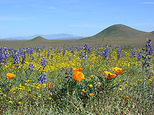
Popies, Lupine, Monolopia
The Carrizo Plain is one of the easiest places to see surface fractures of the San Andreas Fault; they are clearly visible along the eastern side of the plain, at the foot of the Temblor Range. They are best seen in early morning and evening light, when shadows enhance the topography. In addition to its spring wildflower displays, Carrizo Plain is famous for Painted Rock, a sandstone alcove adorned with pictographs created by the Chumash people around 2000 BCE.
State Route 166 passes the south entrance to the Carrizo Plain, and State Route 58 crosses through the northern portion.
Connecting them is the narrow, mostly gravel, Soda Lake Road; the only dependably passable road through the plain—but even this may become impassable when it rains.

Picture left: Pronghorn Male. This antelope once ruled the California desertland but were hunted almost to an extinction. They are fastest land animal that at times can reach 70 miles per hour. They can only run but can not jump over the fence like deers, sustaining more damage on human encroachment.
Wildlife
Spectacular panoramic landscapes, a diversity of wildlife comparable to Africa’s Serengeti, the highest concentration of threatened and endangered wildlife in California—these are the irreplaceable assets of the Carrizo Plain National Monument.
The Carrizo Plain stretches for 250,000 acres along the base of the Temblor Mountains, 60 miles east of San Luis Obispo.
Its vast grasslands, as well as woodland habitats and vernal pools, sustain 15 of California’s threatened and endangered plants and animals.
Here may rest the future of such species as the California jewelflower, San Joaquin kit fox, mountain plover, blunt-nosed leopard lizard, pronghorn antelope and giant kangaroo rat.
The Carrizo Plain is also the largest protected habitat along the Pacific Flyway, making it a birder’s paradise in winter. In spring, Carrizo’s rolling grasslands thrill wildflower enthusiasts with a breathtaking assortment of blooms.

White and blue Lupins on the hillside
After California Poppy Reserve, we left Lancaster and headed north to Mojave, and then drove west on California Highway 58, crossing the southern end of Sierra Nevada Mountains. This is the views of the top of the mountain range. A part of Highway 58 is known as "Kern County Korean War Veterans Memorial Highway". Koreans might have forgotten the war but, as you see, Americans did not forget it. In naming a major highway to the Korean War, they wanted to remember it for a long time.

The southern end of the Sierra Nevada Mountains, here, are not as formidable and high as the northern part.
It is rather gentle and covered with grasses and wildflowers.

A few White Lupines at the roadside with beautiful greenish hillside in the western slope of the Sierra Nevada.
We were blessed with a beautiful day in sunny southern California.

A close up of Adonis Lupines with mix of white and blue color.

We are looking down the "Central Valley" of California. This agricultural land supplies substantial amount of vegetables, fruits, rice, and other grains to entire USA. This is the southern end of the vast plain that extends 500 miles all the way to the northern California. Just below the mountains to the west is Bakersfield, CA.

Owl's Clover (Castilleja densiflora)
Owl Clover is a member of the snapdragon family. The plant grows at elevations between 1500 - 4500 feet in open desert areas. They typically grow to about 6 - 8 inches in height and have green, brushy leaves which are about an inch in length. The Owl Clover blooms in the spring, producing a tiny yellow flower which is surrounded by brushy, purple bracts (bracts are modified leaves which grow at the base of the flowers). The plant is called Escobita in Spanish, which means 'little broom'.
Owl's clover is partially parasitic and blooms from March to May on grassy slopes and openings in chaparral and coastal sage scrub below 3000' and even extending to the w. Mojave Desert. It is highly variable and hybridizes with several other Castilleja species.

Once we pass Bakersfield and cross the Central Valley on highway 58 to the small town of McKittrick, we arrive at the eastern slope of Temblor Range that makes the eastern wall/border of the Carrizo Plain.
We start climbing agian and immediately run into gentle hills with wildflowers.
The first thing that greet us is a hill filled with beautiful pinkish flowers of Owl's Clover.


Walking in the middle of a wildflower field on a beautiful sunny day,
where else could you say the heaven is !!


We continue to climb up the hill passing through the hills covered with yellow wildflowers.


A group of Blazing Star at the roadside.

Yellow Cups in yellow

At the roadside, Lacy Phacelia (in lavender) and Monolopia (in yellow) in full bloom.
Lacy Phacelia (Purple Tansy): A hardy annual, native to California but has naturalized
throughout the western United States. The flowering portion of the stalk is curled, slowly unwinding to reveal lavender colored flowers at maturity. The stamens radiate outward, twice as long as the petals, giving the plant an unusual appearance
Monolopia lanceolata, is a species of flowering plant in the aster (sunflower) family known by the common name common monolopia. It is endemic to the southern half of California, where it grows in many types of habitat, including coastal and valley grassland, chaparral, woodland, and desert. It is an annual herb producing a slender, sometimes branching stem up to about 80 centimeters tall. They are found in Riverside and Orange Counties and north, west Mojave Desert. Blooming period: March to May.

Yellow Monolopia and lavender Lacy Phacelia at roadside.


After a while, we reach the top of the Temblor Range on highway 58. Two bikers stopping for a view.

Old fence and the yellow hillside along the highway.

Monolopia (also known here as Hillside Daisies) covering the hillside.

An old farm house in the valley.

The highway, old farm, wind mills, and cattle feeders along the highway 58.

On the way down the Temblor Range toward Carrizo Plain.

In the field of grasses, yellow and white flowers, we see a few groups of Owl's Clover.
We are in the Carrizo Plain now. As soon as we drive down the western slope of the Temblor Range, we leave highway 58 to take a short cut into Seven Mile Road that meets the northern end of Soda Lake Road.
Then, Soda Lake Road takes us through the entire length of Carrizo Plain National Monument.

Surrounding mountains in the Temblor Range to the east, covered with yellow daisies.
Except spring time when wildflowers bloom, Carrizo Plain is basically a vast field of grasses.
One can see waves of grasses moving along with the passing wind.

A group of Tidy Tips among other wildflowers.

We are entering the Carrizo Plain National Monument.
Many thanks to the US Bureau of Land Management.
This land should be protected forever, so that all of us and wild animals can enjoy together.

We are on Soda Lake Road now.
Soda Lake and the Temblor Range to our left and east.
The hillsides are covered with yellow daisy flowers.
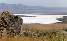
The lake is land-locked and hence there's no outlet.
In ancient times, there was a river draining this area but tectonic deformation caused by the San Andreas Fault blocked the stream and it became a shallow, ephemeral, alkali Endorheic lake during Pliocene-Pleistocene time (Pliocene epoch: 5.3-1.6 million years, Pleistocene epoch: 1.6 million-10,000 years).
At times, rain fills the lake but very soon the blazing desert sun of Southern California will vaporize most of it, leaving behind the salts that were washed down from nearby mountain ranges.


And a huge plain filled with yellow flowers to the west. Beyond is Caliente Range to the west.
We were short of time. Today's total driving was 500 miles back to home.
We dicided to skip Goodwin Education Center and "Painted Rock", located away from Soda Lake Road. The visitor center should have a lot of information about the National Monument.
We were driving through and looking at the unimaginable changes that the geological time have patiently prepared for us during the last few million years.
Yet, we were short of just a few hours in our driving time to skip some of the wonderful nature's showcase presented to us.
What a pity !! Nevertheless, we drive on the dirt road of Carrizo Plain to southeast.

To the direction of Caliente Range, the plain is covered with wildflowers and grasses.


We missed San Andreas fault as we passed Seven Mile Road earlier as we were entering Carrizo Plain. It seems that the road construction had covered up the surface change caused by the geological change by the fault activities.
Now at the southern end of Carrizo Plain, we came upon a series of wide gaps where the land had become splitted and opened.
Left: Aerial photo of SanAndreas in Carrizo Plain.
San Andreas Fault: The most prevalent geologic feature of the Carrizo plains is the San Andreas Fault. It is a right lateral fault which runs along the northeast of the Plain, at the base of the Elkhorn Scarp, and forms the boundary between the Pacific and North American Plates. Although the fault runs through California all the way from Cape Mendocino to just south of Los Angeles, the Carrizo plain remains one of the best places to study it. The section of fault line in the Carrizo plain is the oldest section of the San Andreas Fault and displays the largest accumulated offset of the post-early Miocene. Its motion has shaped the broad geomorphic features of the valley, creating the ridges and ravines and altering the paths of several creeks; decapitating some altogether.
(Miocene Epoch: 23.8-5.3 million years)

One time, this could have been a bottomless pit. It's all filled up since.
More filling by the road contruction as Soda Lake Road goes across it.

Another salt lake at the southern end of the National Monument. The salt deposit shows at the shore.
Some texts from the Internet, Photo (April 7, 2010) by SNUMA WM - August 24, 2010


 이곳을 "Great Central Valley" 라고도합니다.
더 수정과 보탬을 가해야겠지요.