


- Total
- General
- Arts
- Book
- Culture
- Economy
- Essay
- Fun/Joke
- History
- Hobbies
- Info
- Life
- Medical
- Movie
- Music
- Nature
- News
- Notice
- Opinion
- Philosophy
- Photo
- Poem
- Politics
- Science
- Sports
- Travel
Travel Utah Hiking 2009 (1) - Corona Arch & Bowtie Arch, Moab
2009.11.14 15:04
Corona Arch, Moab, Utah
In Moab city's information brochure, it says,"If you have time only for one hiking, go to Corona Arch." Bowtie Arch is adjacent to Corona Arch, formed in a different geologic process. Both arches are side by side. Much of the route is exposed to the sun and there is little shade available. During hot weather an early morning or evening hike is recommended. Every member of your hiking party should carry at least one liter of water. This hike should be easily accessible year round. Navigation for this hike is easy. The route is well marked with cairns. Just follow the cairns on slick rocks and occasional sandy trails. There are steel cables and ladder on the way to assist those who are not used to rocky slopes. Most people could climb without them.  Trailhead Information: Trailhead Information:From Moab, head north out of town on U.S. Highway 191. Cross the bridge over the Colorado River. After crossing the bridge continue north for 1.3 miles to the signed "Potash" road, which is State Road 279 (about 4 miles from Moab). Turn west (left) and follow State Road 279 along the Colorado River for 10.1 miles to the signed Corona Arch trailhead. The trailhead is located on the north (right) side of the road. The trailhead consists of a large gravel parking lot and an information kiosk. If you have time, drive along the Colorado River to Potash. The canyon is magnificent on both sides of the river. You will know that you are in the world's best canyon and mesa country. You might want to stop and look at the Potash Petroglyphs and Dinosaur Tracks on the drive to the trailhead. You pass right by them and they only require a couple of minutes extra to enjoy. Gold Bar Campground and picnic site are located across the road from the Coronaq Arch trailhead, on the shore of the Colorado River. It has picnic tables and bathroom facilities. For more information or for reservations, please call the Bureau of Land Management Moab Field Office at (435) 259-2100. Route Information:From the Corona Arch Trailhead (N38º 34' 28", W109º 37' 57"), follow the trail as it climbs east to a BLM register located on a small bench where you will also cross the railroad tracks. After crossing the railroad tracks follow an old eroded road bed through a gap in the slickrock bench above. After reaching the top of the bench the route follows a trail of cairns (little piles of rock) northeast towards the base of a large sandstone cliff. Follow the base of the cliff east to a safety cable that protects a slightly exposed section of trail. Corona Arch is visible from this point. After the first safety cable continues to follow the base of the cliff to a second safety cable and moki steps carved into the sandstone. Climb to the top of the moki steps. From the top of the moki steps continues east, climb a short ladder up over a ledge and follow the cairns up to the top of a large bench. From this point, it is easy to walk along the wide slickrock bench, beneath Bowtie Arch (N38º 34' 28", W109º 37' 19"), and on to the base of Corona Arch (N38º 34' 47", W109º 37' 12"). Please be careful of steep drop-offs along the trail. Arch Bagging Variation:For those who would like to visit the top of Corona Arch here is what you need to know. 50 yards east of Corona Arch is a steep buttress that has moki steps carved into it. The steep buttress allows access to a ledge system and the top of Corona Arch. The moki access is exposed and a fall could be deadly. Going up the buttress is much easier then coming down. There are several pitons and bolted anchors in the buttress that might offer some protection if you have a 60 meter rope for belays and handlines.
When I saw the railroad tract coming out between the rocks from nowhere, I wondered how it could be. Some of the information data came from the Internet and "Climb-utah.com" |
 Eight of us got together in Las Vegas and drove 7 hours on I-70 to arrive Moab, Utah last night.
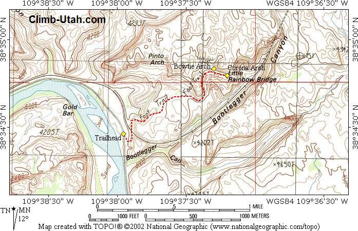


Comment 4
-
방준재*70
2009.11.14 21:51
-
황규정*65
2009.11.15 02:52
마침 한국 가는때와 같은때라 동참할수 없었던것이 유감이며
무사히 성공리에 유타 하이킹을 하신 친구분들께 축하드립니다.Certainly I missed the Utah hiking as well as those breath-taking sceneries! 규정
-
운영자
2009.11.15 03:27
Hi, Dr. Bang,
If there's anything, it's a love of nature between us two.
It's a love about real things that do physically exist and finding them where they are.
They do not run away from me or change their minds.
Therefore, if only I can walk, all I have to do is just to walk to them.
There will be a series of "Utah Hiking" from now on for a while.
Having made the trip was one thing, an easier part,
but summarizing and filing it all together into a journal is another.
It will take some time to finish, if I ever get to do it. -
운영자
2009.11.15 18:13
In appreciation of those friends who came and hiked together....
This was a very unusual trip. When I came back to California and weighed myself
after a shower, I found myself 2 pounds heavier !! Such thing never happened before.
Everyday, we marched 7-10 miles on the rough trails and then came back with weight gain ??
I couldn't believe it but my electronic scale doesn't lie.
Looking back, the weight gain must have been due to the "Cup 떡국 with 밥 added"
in the morning meal. Another thing was the dinner with Korean "밥".My sincere thanks to Dr. and Mrs. Chai who came over to prepare lunch sandwiches.
My big thanks to my wife and Mrs. Chai who took care of the general food preparations.
We went to Moab, Utah and had done what we went for.
Everything went very well and we fulfilled our goal to my satisfaction.
I can not thank enough to the participating friends.
Without their helps, willingnesses, and their companies, the job couldn't have been achieved.At our age, I am very proud of you.
Guys and gals, thanks again. It was a blast.
| No. | Subject | Date | Author | Last Update | Views |
|---|---|---|---|---|---|
| Notice | How to write your comments onto a webpage [2] | 2016.07.06 | 운영자 | 2016.11.20 | 18193 |
| Notice | How to Upload Pictures in webpages | 2016.07.06 | 운영자 | 2018.10.19 | 32343 |
| Notice | How to use Rich Text Editor [3] | 2016.06.28 | 운영자 | 2018.10.19 | 5919 |
| Notice | How to Write a Webpage | 2016.06.28 | 운영자 | 2020.12.23 | 43838 |
| » | Utah Hiking 2009 (1) - Corona Arch & Bowtie Arch, Moab [4] | 2009.11.14 | 운영자 | 2009.11.14 | 3805 |
| 451 | 제주 기행 ( I ) [3] | 2009.11.16 | 유석희*72 | 2009.11.16 | 8679 |
| 450 | Utah Hiking 2009 (2) - Onion Creek & Thompson Canyon | 2009.11.17 | 운영자 | 2009.11.17 | 3533 |
| 449 | 제주 기행( II ) [2] | 2009.11.19 | 유석희*72 | 2009.11.19 | 8521 |
| 448 | 또 다른 제주이야기( I ) | 2009.11.19 | 유석희*72 | 2009.11.19 | 8200 |
| 447 | 제주 기행( III ) [2] | 2009.11.21 | 유석희*72 | 2009.11.21 | 7973 |
| 446 | 제주 기행( 마지막 편) [6] | 2009.11.27 | 유석희*72 | 2009.11.27 | 7542 |
| 445 | Los Verdes GC, LA County, CA 2009 [4] | 2009.12.06 | 조동준*64 | 2009.12.06 | 7495 |
| 444 | 충남 태안에서 식사를 [6] | 2009.12.10 | 유석희*72 | 2009.12.10 | 7413 |
| 443 | 2009년 6월 캐나다 록키 여행 [10] | 2009.12.10 | 계기식*72 | 2009.12.10 | 6753 |
| 442 | Romantic Germany I, 2009 [8] | 2009.12.13 | 조성구*65 | 2009.12.13 | 7861 |
| 441 | 욕지도 관광 [1] | 2009.12.14 | 유석희*72 | 2009.12.14 | 8033 |
| 440 | 일본 하코네 여행 (2008년) [7] | 2009.12.15 | 계기식*72 | 2009.12.15 | 6615 |
| 439 | Romantic Germany, II [8] | 2009.12.17 | SungjaCho#65 | 2009.12.17 | 7084 |
| 438 | 일본 오사카 여행 (2008.5) [6] | 2009.12.18 | 계기식*72 | 2009.12.18 | 6842 |
| 437 | Romantic Germany III; Heidelberg [5] | 2009.12.20 | SungjaCho#65 | 2009.12.20 | 8650 |
| 436 | 고성 거류산과 몽골(독수리를 찾아서) [2] | 2009.12.21 | 유석희*72 | 2009.12.21 | 8259 |
| 435 | 불타버린 향일암 [2] | 2009.12.23 | 유석희*72 | 2009.12.23 | 8961 |
| 434 | 천도제를 올리고 나서 [6] | 2009.12.29 | 유석희*72 | 2009.12.29 | 6975 |
| 433 | 천도제를 올리고 나서.. [7] | 2009.12.29 | 유석희*72 | 2009.12.29 | 7474 |
It's a silly question asking you,"what did you find there?".